Hydrology Reports & Water Management Assessments in Devon & Cornwall
Pond Design | Wetland Creation | Rewilding & Regenerative Land Management
Practical hydrology reports and water management assessments for wildlife ponds, wetlands, habitat creation, natural swimming ponds, farms and estates.
Intro
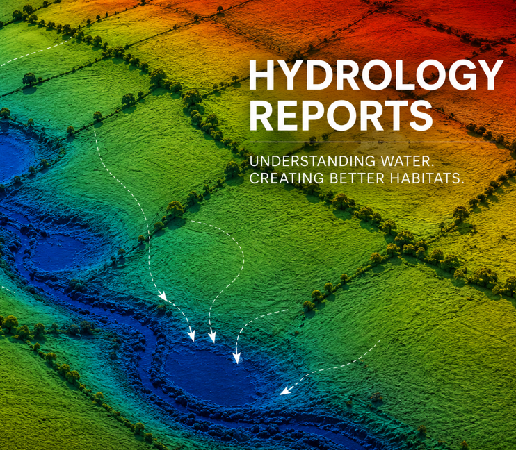
Understanding how water moves through a site is often the most important factor in the success of a pond, wetland or habitat creation project.
Drawing on extensive experience designing and constructing ponds and wetlands throughout Devon and Cornwall, we provide practical hydrology reports and water management assessments to help landowners, architects, planning consultants and project teams make informed decisions.
Our reports focus on real-world project delivery and can be used to support habitat creation projects, planning applications, grant schemes and wider land management objectives.
What Is A Hydrology Report?
A hydrology report helps identify:
- Existing water sources
- Surface water movement
- Drainage patterns
- Seasonal water levels
- Flood risk considerations
- Opportunities for ponds and wetlands
- Water retention opportunities
- Habitat creation potential
The objective is to understand how water behaves across a site and how this can be used to create successful and sustainable environmental projects.
Why Hydrology Matters
Many environmental projects fail because insufficient consideration is given to how water moves through the landscape.
A well-prepared hydrology assessment can help identify:
- Suitable pond locations
- Wetland opportunities
- Natural flood management measures
- Water storage opportunities
- Habitat enhancement potential
- Areas prone to seasonal flooding
- Constraints that may affect project delivery
Understanding these factors at an early stage can save significant time and cost later in the project.
Projects We Commonly Support
Wildlife Pond Projects
Assessing water availability, catchment characteristics and opportunities for successful pond creation.
Wetland Creation & Restoration
Understanding water movement and seasonal variation to inform wetland design and restoration.
Natural Swimming Ponds
Assessing water supply, site drainage and opportunities for integrating swimming ponds within the wider landscape.
Farm & Estate Projects
Supporting larger-scale habitat creation, water management and land stewardship initiatives.
Grant Funded Environmental Projects
Providing supporting information for habitat creation schemes and environmental funding opportunities.
Typical Assessments May Include
- Site inspection
- Existing water source assessment
- Catchment observations
- Drainage observations
- Water level observations
- Pond feasibility assessment
- Wetland feasibility assessment
- Habitat creation opportunities
- Natural flood management opportunities
- Supporting plans and mapping
- Practical recommendations
The scope of each report is tailored to the specific project and site.
Planning & Grant Support
Hydrology reports can often form part of a wider package of environmental support services.
We regularly assist with:
- Planning support documents
- Habitat creation proposals
- Biodiversity enhancement plans
- Grant supporting documents
- Land management advice
Where specialist engineering or ecological input is required, we can work alongside other professionals as part of the wider project team.
Why Choose SAS Aquatics?
Unlike many consultants, we don’t just write reports.
We design, build and restore ponds, wetlands and habitat projects throughout Devon and Cornwall.
This practical experience allows us to provide realistic recommendations that consider construction feasibility, long-term management and ecological value from the outset.
Devon & Cornwall
Discuss Your Project
Planning a wildlife pond, natural swimming pond, wetland or habitat project? Send us your photos, videos and ideas and we’ll be happy to help.
What is a hydrology report, and why do I need one?
A hydrology report analyses how water moves across your land — including rainfall, infiltration, runoff, and drainage patterns.
At Sasaquatics, we use this information to design ponds, swales, and wetlands that capture water efficiently, prevent erosion, and support biodiversity. It ensures your investment in pond or rewilding works is resilient and well-planned within the wider landscape.
How much does a hydrology report cost?
For most sites in Devon or Cornwall (10–25 acres), our Hydrology & Water Feature Design Report starts from £1400.
This includes catchment analysis, GIS mapping, rainfall-runoff calculations, pond and swale design, planting plans, and funding guidance for schemes such as ELMS Local Nature Recovery and Rewilding Britain Innovation Fund.
Do you only work in Devon and Cornwall?
Our focus area is Devon and Cornwall, including Totnes, Truro, Tavistock, Exeter, Bodmin, Perranporth, and surrounding areas — generally within 1.5 hours of Moretonhampstead.
However, we occasionally take on larger or high-impact projects across southern England where rewilding and water restoration are central to the design.
Can you design and build the ponds as well?
Yes. Sasaquatics offers both consultancy and hands-on implementation.
After your hydrology report is complete, we can carry out excavation, GCL liner installation, swale formation, and ecological planting — ensuring design and construction align perfectly.
Will my project qualify for funding or grants?
Quite possibly. Most landowners in Devon and Cornwall are eligible for one or more environmental support schemes, including:
ELMS – Local Nature Recovery (habitat creation & hydrology improvements)
Rewilding Britain Innovation Fund
Cornwall Climate & Nature Fund / Catchment Partnerships
We identify the best match and provide the mapping and evidence base required for applications.
What types of sites do you work with?
We work with a wide range of clients including private landowners, smallholders, farmers, community groups, and conservation charities.
Our projects range from 5-acre regenerative smallholdings to 100-acre farm clusters — anywhere water and wildlife need to be reconnected.
How long does it take to complete a report?
Typically 1-2 weeks from confirmed instruction, depending on weather, data collection, and design complexity.
We can also fast-track for funding deadlines when needed.
Do you use sustainable or plastic-free materials?
Yes — where possible, we use Geosynthetic Clay Liners (GCL) instead of plastic liners.
These natural, durable materials seal ponds effectively while aligning with regenerative and low-impact construction principles.
Can a hydrology report support planning permission or eco-house applications?
Absolutely. Our reports can be used as supporting evidence for planning applications under Cornwall’s Policy AL1 or similar sustainability frameworks, especially where water management and habitat creation are part of the proposal.
What areas of Devon and Cornwall do you cover?
We regularly work in:
Devon: Moretonhampstead, Totnes, Exeter, Crediton, Tavistock, Dartmoor fringes
Cornwall: Truro, Perranporth, St Austell, Bodmin, Launceston, and the Fal and Fowey catchments
Can you confirm whether a pond will hold water?
We can assess site conditions and provide recommendations. In some situations, trial pits or further investigations may be recommended before construction.
Do you provide engineering reports?
No. We provide practical hydrology assessments and water management reports. Where specialist engineering input is required, we can work alongside suitably qualified professionals.
Do I need a hydrology report for a pond?
Not always. Smaller wildlife ponds may not require a formal report, but larger projects, grant-funded schemes and planning applications often benefit from a hydrology assessment.